Bingie Residents Association Bingie Landscape
|
A Geological Summary...
The Bingie landscape is the product of a long geological history extending back to about 490 million years ago (approximately the last 11% of the earth’s existence). The present landforms were largely determined by the underlying rocks and the processes that they have been subjected to. The major processes that have influenced the formation of landscapes have been happening continuously over billions of years & are still happening today. They Include continental drift causing uplift (mountain building) and subduction (rocks being dragged down to depths of 15 to 20 kilometres), weathering, erosion, transport of eroded material and deposition and climate changes causing sea level rises and falls. Other contributing factors include the introduction and continued development of plants and animals on the land and human activities such as land clearing, farming, road building, mining and housing in villages, towns and cities. |
|
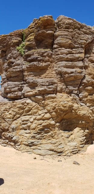
Weathered 29 million year old Coila Basalt at Congo
|
Five rock types exist in the Bingie area. These are meta-sediment, tonalite and gabbroic diorite (types of granitic rocks), basalt and soft pebbly sandstone. Soils formed over these rocks vary from poorly fertile over the meta-sediment, tonalite and soft sandstone, to moderately fertile over basalt and gabbroic diorite. Water percolating through the porous soft sandstones has dissolved silica and re-deposited it as silcrete in places.
Long periods of weathering and erosion over millions of years have reduced a once mountainous landscape to one of low rolling hills and valleys. Rivers and creeks have deposited gravel where they emerge from the mountains to the west, and fertile soil in floodplains as they progress towards the coast. Much of the eroded material has been washed to the ocean, where fine silt and mud has been separated from sand and deposited under deep oceans far from land. Ocean currents and waves have deposited the sand where valleys meet the sea to form beaches, and have eroded the rocks on higher ground to form rock platforms and cliffs. Climate changes over the past 2.3 million years have caused rises and falls in the sea level as much of the water on the earth’s surface froze and thawed. Temperatures warmer than present at about 120,000 years ago caused the sea level to be about 5 metres higher than now and remnant sand dunes formed at that time still exist in this area today. Freezing temperatures about 20,000 year ago caused a major drop in the sea level of about 125 metres resulting in the coast being some 15 kilometres further east. Warming over the next 14,000 years caused much of the ice to melt and the sea level to rise to approximately the current level. For more detailed information about our local geology please download the document below!
| ||