Bingie Residents Association Water Quality Monitoring Project 2003-2018

|
NSW Waterwatch Bingie Residents Water Quality Monitoring Program
The program This activity began in 2003 when the NSW water resources authority selected several small coastal catchments and requested local Landcare groups to undertake a community water monitoring program. The objectives were to establish information on the quality of stream and estuarine water and to identify changes in the parameters measured. A longer-term objective was to identify causes of poor water quality, and to mitigate actions that might be causing water quality problems. The NSW Waterwatch program was funded from government grant sources, and both the water monitoring agencies and the sources of grant funding have changed over time, with direct funding to communities having ceased several years ago. Despite this, with the support of various state and Commonwealth government agencies, many community groups (including our Association) continued to collect samples and undertake the testing program. Bingie Residents Association had a Landcare Group for some years but after the Landcare program was modified all associated conservation/landcare activities were subsumed into the wider Association program, and this included the water quality monitoring. |
|
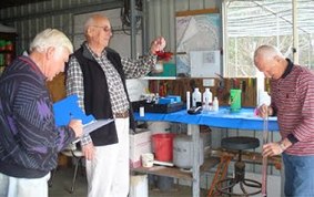
What we do in the field and the lab
Each original group was assigned a set of monitoring points and was provided with a field test kit and a manual describing the process for measuring and recording a range of water quality variables. The managers of the overall program (most recently OEH in 2010) changed some of the protocols after the first few (trial) years, and a set of identified and reliably testable parameters has now been established for more than 10 years. Bingie residents monitor six stations (3 freshwater streams and the 3 estuaries they drain into) on a monthly basis: Stinky Creek and Mullimburra Lagoon, Kelly Creek and Kelly Lake (also known as Bingie ICOLL), |
Cudbagga Creek and its opening into Coila Lake. Generally two people visit each site and collect the water samples which are analysed in a ‘home laboratory’. Dieter Klein undertook the analysis for the first 10 years, Geoff Scott followed for an interim year, and Philip Hughes and Marjorie Sullivan have undertaken the analyses since 2015.
What happens to the data?
We have been told by the program’s managers (a diminishing and increasingly overworked group, as governments generally fail to appreciate the research value of long-tern scientific monitoring) that the Bingie record is now the longest and most constant record in NSW. Volunteers collect the samples and carry out the analyses. OEH, in conjunction with CSIRO, established a web-based reporting system, and each month the results of the analyses are entered into that system. A copy of each month’s summary and brief reporting note is also sent to all the collectors and to the Association’s Chair/Secretary.
The NSW Waterwatch database allows Waterwatch groups to enter water quality monitoring results from their local area or chosen site. The information is then used by Local Land Services and other organisations to develop an indication of water quality/health in a particular area. The information collected may also provide an indication of upstream catchment health and what other factors may be impacting the health of a lake, river or estuary.
Long-term data sets are valuable research resources, and we have always considered it valuable to continue with the monitoring program, especially in the face of climate-induced changes that might be becoming apparent. There is however a cost to the Association: chemical reagents have to be replenished as they are used, and occasionally collection or analysis items or measuring instruments have to be replaced. The cost to the Association is about $300 annually.
What is happening to water quality over time?
Those of us involved in the analyses believe there are interesting results that can be drawn from the long-term data record, with some work, and could lead to a small scientific publication. So far all that has been done towards this is to ensure the record is uniform in format, and in a form that can quickly be sorted/searched electronically. Based on nothing more than our observations of the records however, we think there are some interesting findings:
· Rainfall is the key determinant of water quality in the Bingie catchments. Water quality deteriorates during prolonged warm dry periods.
· Water quality is good, and encouragingly has generally improved over time as the catchments have been re-vegetated and left largely undisturbed. This is despite the local population increasing dramatically in recent years. ‘Hobby farmers’ are good land managers and Bingie residents have a strong land conservation approach to managing their blocks.
· Phosphorus compounds are associated with animal (including human) wastes and indicate excess nutrients entering the water bodies. Occasional inputs of phosphates into the streams occur if a septic system overflows (very rare), if a land owner disturbs the ground near a stream bank, and (most commonly) when cattle or horses wade into the stream, or heavy rain washes animal manure into the streams from adjacent paddocks.
· Oxygen levels are generally good but fall when water becomes eutrophic (in warm dry conditions). Wind-driven waves and good inflows of turbulent water after rain re-oxygenate the water.
· Occasionally the small ICOLLS (estuaries) become hyper-saline, much more saline than seawater, when they are closed and water evaporates from their surfaces. This happens to the large Coila ICOLL only during long dry periods.
· Rainfall in this area has reduced over the last few decades. If this trend continues with climatic warming and more extended El Nino-like conditions, it is likely water quality in these small coastal catchments will deteriorate.
For the actual result spreadsheets please click here to go to the results page.