Bingie Residents Association Greater Glider Project
This project is in development.
What is the project?
This project aims to map the population of Greater Gliders in Bingie - Congo area, and improve habitat and wildlife corridors to support the population.
Habitat objectives include connecting local forest to larger forest areas adjacent to Bingie-Congo.
Background
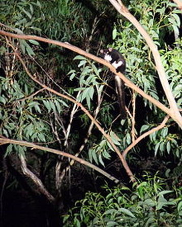
Greater Gliders (GGs) are present in the area and were a focus of BRA’s Landscape Plan developed in 2005 (ref.1). They are nocturnal and move about high up in the trees, so they are not often seen by casual observers.
Although GGs have a small home territory, they need to interbreed with a large population for genetic diversity and population health. They move about by climbing high in the tree and gliding to the next tree. 40 metres is considered on average the maximum distance between mature trees for safe movement. The shorter the trees, the closer they need to be. When forced to do so, gliders will descend to the ground but their movement is slow and clumsy and they are at great risk of predation by dogs and injury or death from road traffic. Habitat loss and habitat fragmentation (such as by unnecessarily wide road corridors) are therefore a major threat.
Mapping also helps build the case for preserving forest areas an appropriate scale road development.
Developments so far…
NSW Department of Environment and Heritage has provided (on loan!) two excellent torches for mapping and some large maps with previous sightings mapped. These are available from Steve Druitt phone 0451 679 960 or email [email protected]. The mapping is designed as a community mapping project with local residents adding to the map as they make sightings.
Mapping is easy with smartphone and an app called NatureMapr. BRA is planning a workshop early in 2018 to familiarise residents with the app. Information upload via the app is monitored by expert staff and recdorded on the Atlas of Life in the Coastal Wilderness. Sightings can also be recorded through the website http://atlasoflife.naturemapr.org/
The site also links and records on national and international resources.
What you can do:
- ensure if you are going to survey for gliders that you get clearance from the coordinator (Steve Druitt 0451 679 960) and follow the guidelines. (See current draft guidelines below)
- get the mapping skills, borrow the equipment, map and record any Greater Gliders on your property or nearby if you have access.
- preserve mature trees on your property, consider planting to maintain the canopy. What is the best way to balance this objective with fire safety on your property?
- consider the trees on your property - are they ‘connected up’ (less than 40 metres apart for mature trees)? Would further planting help?
- are the trees on your property connected to nearby forest? Can you work with neighbours to improve habitat and connection corridors? Is this something to ask wider community to work on with you?
- join in planting projects when they are announced.
Draft Survey Guidelines:
(These guidelines are being reviewed by NPWS and may change)
- arrange survey trips with a coodinator to ensure guidelines are being met ( Coordinator: Steve Druitt 0451 679 960)
- Not more than once a month in the same area
- vary times of night for surveying
- maximum number of surveys in one area per year: ?
- do not spend more than (15 minutes?) on one particular sighting
- wear durable outdoor protective clothing and footwear.
- survey in pairs
- register survey date and time and names of surveyors with Coordinator
Reference
What is the project?
This project aims to map the population of Greater Gliders in Bingie - Congo area, and improve habitat and wildlife corridors to support the population.
Habitat objectives include connecting local forest to larger forest areas adjacent to Bingie-Congo.
Background
Greater Gliders (GGs) are present in the area and were a focus of BRA’s Landscape Plan developed in 2005 (ref.1). They are nocturnal and move about high up in the trees, so they are not often seen by casual observers.
Although GGs have a small home territory, they need to interbreed with a large population for genetic diversity and population health. They move about by climbing high in the tree and gliding to the next tree. 40 metres is considered on average the maximum distance between mature trees for safe movement. The shorter the trees, the closer they need to be. When forced to do so, gliders will descend to the ground but their movement is slow and clumsy and they are at great risk of predation by dogs and injury or death from road traffic. Habitat loss and habitat fragmentation (such as by unnecessarily wide road corridors) are therefore a major threat.
Mapping also helps build the case for preserving forest areas an appropriate scale road development.
Developments so far…
NSW Department of Environment and Heritage has provided (on loan!) two excellent torches for mapping and some large maps with previous sightings mapped. These are available from Steve Druitt phone 0451 679 960 or email [email protected]. The mapping is designed as a community mapping project with local residents adding to the map as they make sightings.
Mapping is easy with smartphone and an app called NatureMapr. BRA is planning a workshop early in 2018 to familiarise residents with the app. Information upload via the app is monitored by expert staff and recdorded on the Atlas of Life in the Coastal Wilderness. Sightings can also be recorded through the website http://atlasoflife.naturemapr.org/
The site also links and records on national and international resources.
What you can do:
- ensure if you are going to survey for gliders that you get clearance from the coordinator (Steve Druitt 0451 679 960) and follow the guidelines. (See current draft guidelines below)
- get the mapping skills, borrow the equipment, map and record any Greater Gliders on your property or nearby if you have access.
- preserve mature trees on your property, consider planting to maintain the canopy. What is the best way to balance this objective with fire safety on your property?
- consider the trees on your property - are they ‘connected up’ (less than 40 metres apart for mature trees)? Would further planting help?
- are the trees on your property connected to nearby forest? Can you work with neighbours to improve habitat and connection corridors? Is this something to ask wider community to work on with you?
- join in planting projects when they are announced.
Draft Survey Guidelines:
(These guidelines are being reviewed by NPWS and may change)
- arrange survey trips with a coodinator to ensure guidelines are being met ( Coordinator: Steve Druitt 0451 679 960)
- Not more than once a month in the same area
- vary times of night for surveying
- maximum number of surveys in one area per year: ?
- do not spend more than (15 minutes?) on one particular sighting
- wear durable outdoor protective clothing and footwear.
- survey in pairs
- register survey date and time and names of surveyors with Coordinator
Reference
- Bingie Landscape Planning Project, 2006. Bingie Landcare Group, Eurobodalla Shire Coluncil. (Gaia Research Pty Ltd).